Viral Hooks
Trending short videosAerial view of highway landslide
W

@wsdot

Instagram · Carousel
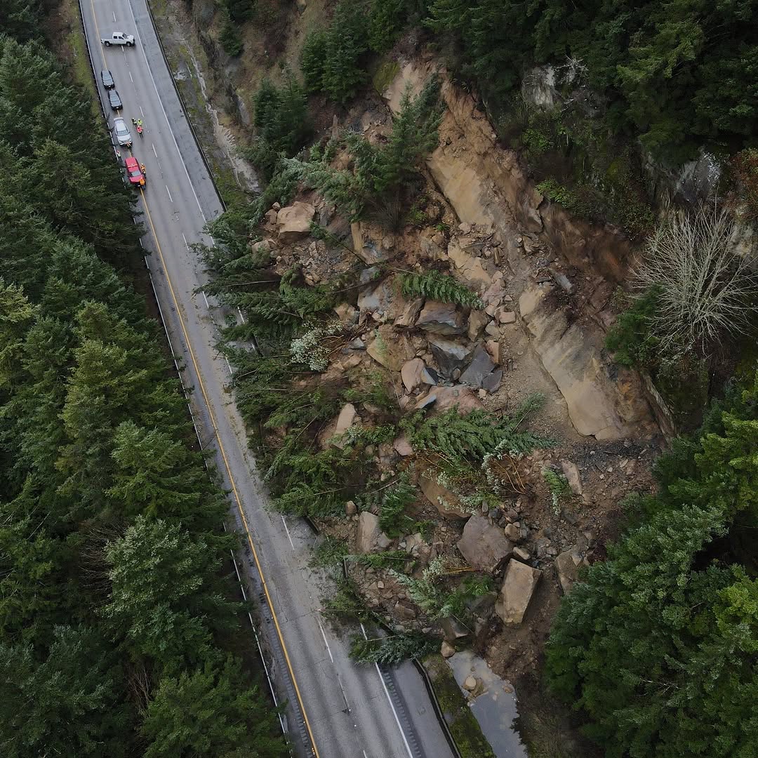
@wsdot A top-down view of the slides blocking NB I-5 south of Bellingham. This one’s a doozy, as active movement on the slope is preventing crews from safely beginning cleanup. A large rock, bigger than a bus (and bigger than a small boulder), has already fallen 60–80 feet and remains unstable and unsupported.  NB I-5 will like remain closed overnight. Alternate routes are available via SR 9 and SR 11, but SR 11 and local roads are not suitable for freight. We know this is frustrating, but cleanup isn’t just a matter of loading debris into trucks. Our crews have to be precise and methodical to ensure it’s done safely. The first three photos are courtesy of @finnwendtphoto / @cascadiadaily The other two photos are from our crew on the ground
View original on Instagram

Performance

Views
424.6K
Likes
28.3K
Comments
375
Engagement
6.8%
Outlier
5.9×

Video #21937 · Carousel

Aerial view of highway landslidefrom @wsdot

[01]

Overview

An aerial photograph documenting a severe landslide that has completely blocked the northbound lanes of Interstate 5, utilized by a civic or news organization to inform the public about road closures, safety hazards, and cleanup efforts.

[03]

Related videos

[04]

Classification

Format
Concepts
News CarouselPublic Service Announcement
Elements
Overhead Shot
Account

[05]

Hook analysis

What stops the scroll in the first 3 seconds

Verbal hook · 25%

A top-down view of the slides blocking NB I-5 south of Bellingham. This one’s a doozy

Visual hook · 75%

Dramatic top-down aerial view showing the massive scale of a landslide completely burying a multi-lane highway, with giant boulders and uprooted trees contrasting sharply against the paved road surface.

[06]

Hook template

Steal this for your own video

A dramatic top-down aerial view of [unexpected event] completely overtaking [familiar place].

  • — A dramatic top-down aerial view of a flash flood completely overtaking a neighborhood street.
  • — A dramatic top-down aerial view of a sinkhole completely overtaking a city intersection.
  • — A dramatic top-down aerial view of a sandstorm completely overtaking an outdoor festival.

Themes

  • Natural Disasters
  • Public Infrastructure
  • Community Safety

Techniques

  • Drone Photography
  • Top-Down Perspective
  • Scale Comparison

Trends

  • Real-time civic updates
  • Sourced citizen photojournalism

Post caption

A top-down view of the slides blocking NB I-5 south of Bellingham. This one’s a doozy, as active movement on the slope is preventing crews from safely beginning cleanup. A large rock, bigger than a bus (and bigger than a small boulder), has already fallen 60–80 feet and remains unstable and unsupported.  NB I-5 will like remain closed overnight. Alternate routes are available via SR 9 and SR 11, but SR 11 and local roads are not suitable for freight. We know this is frustrating, but cleanup isn’t just a matter of loading debris into trucks. Our crews have to be precise and methodical to ensure it’s done safely. The first three photos are courtesy of @finnwendtphoto / @cascadiadaily The other two photos are from our crew on the ground
Aerial view of highway landslide | Viral Hooks